France
Landes coastfrom Capbreton
A 24.5 km flat loop from Capbreton: 147 m of climbing in all. Grimpa draws the real road in pixel art, and your smart trainer holds your watts the whole way.
Part of the Pyrenees & Basque Country map pack: 6 routes for €4.99, kept for good. Every item in it is earned by riding.
See the pack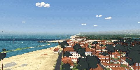
The profile
Along the road
- Capbretonkm 0.0 · 3 m
- Hossegorkm 3.5 · 4 m
- Les Estagnotskm 6.5 · 5 m
- Le Penonkm 9.5 · 6 m
- Seignossekm 15.1 · 19 m
- Soortskm 18.5 · 15 m
Kilometre by kilometre
The average gradient of every kilometre, as your trainer will feel it.
| Km | Altitude | Gradient |
|---|---|---|
| 1 | 5 m | 0.2 % |
| 2 | 4 m | -0.1 % |
| 3 | 6 m | 0.2 % |
| 4 | 4 m | -0.2 % |
| 5 | 4 m | 0.0 % |
| 6 | 4 m | 0.0 % |
| 7 | 7 m | 0.3 % |
| 8 | 4 m | -0.3 % |
| 9 | 5 m | 0.1 % |
| 10 | 10 m | 0.5 % |
| 11 | 15 m | 0.5 % |
| 12 | 32 m | 1.7 % |
| 13 | 16 m | -1.6 % |
| 14 | 24 m | 0.8 % |
| 15 | 20 m | -0.4 % |
| 16 | 23 m | 0.3 % |
| 17 | 18 m | -0.5 % |
| 18 | 17 m | -0.1 % |
| 19 | 7 m | -1.0 % |
| 20 | 5 m | -0.3 % |
| 21 | 7 m | 0.3 % |
| 22 | 10 m | 0.2 % |
| 23 | 4 m | -0.6 % |
| 24 | 4 m | -0.0 % |
| 25 | 3 m | -0.2 % |
Built from the real road
Every bend and every gradient is where it is on the mountain: the road and the villages from OpenStreetMap, the land from OpenStreetMap and IGN, the height of every metre from IGN and Mapterhorn. All open data, listed on the sources page.
What you need
A smart trainer with Bluetooth, or your bike with a power meter, and Chrome or Edge on a computer or an Android phone. Sign in with your email or Google; the ride saves to Strava.
More climbs
- Mont Ventouxfrom Bédoin
- Col de la Ginestefrom Marseille
- Dentelles de Montmirailfrom Malaucène
- Cap d'Antibesfrom Antibes
- Flanders Fieldsfrom Heuvelland
- Flemish Ardennesfrom Oudenaarde
- Arenbergfrom Wallers
- Damme–Sluisfrom Damme
- Alpe d'Huezfrom Le Bourg-d'Oisans
- Passo dello Stelviofrom Prato allo Stelvio
- Sa Calobrafrom Sa Calobra
- Alcúdia Bayfrom Port de Pollença
- Col du Tourmaletfrom Luz-Saint-Sauveur
- Hautacamfrom Argelès-Gazost
- Col d'Aubisquefrom Argelès-Gazost
- Jaizkibelfrom Hondarribia
- Basque villagesfrom Ascain